Table of contents
Browse categories
Browse authors
 AL
ALAlessia Longo
 AH
AHAl Hoge
 BJ
BJBernard Jerman
 BČ
BČBojan Čontala
 CF
CFCarsten Frederiksen
 CS
CSCarsten Stjernfelt
 DC
DCDaniel Colmenares
 DF
DFDino Florjančič
 EB
EBEmanuele Burgognoni
 EK
EKEva Kalšek
Franck Beranger
 GR
GRGabriele Ribichini
Glacier Chen
 GS
GSGrant Maloy Smith
 HB
HBHelmut Behmüller
 IB
IBIza Burnik
 JO
JOJaka Ogorevc
 JR
JRJake Rosenthal
 JS
JSJernej Sirk
 JM
JMJohn Miller
 KM
KMKarla Yera Morales
 KD
KDKayla Day
 KS
KSKonrad Schweiger
Leslie Wang
 LS
LSLoïc Siret
 LJ
LJLuka Jerman
 MB
MBMarco Behmer
 MR
MRMarco Ribichini
 ML
MLMatic Lebar
 MS
MSMatjaž Strniša
 ME
MEMatthew Engquist
 ME
MEMichael Elmerick
Nicolas Phan
 OM
OMOwen Maginity
Patrick Fu
 PR
PRPrimož Rome
 RM
RMRok Mesar
 RS
RSRupert Schwarz
 SA
SASamuele Ardizio
 SK
SKSimon Kodrič
 SG
SGSøren Linnet Gjelstrup
 TH
THThorsten Hartleb
 TV
TVTirin Varghese
 UK
UKUrban Kuhar
Valentino Pagliara
 VS
VSVid Selič
 WK
WKWill Kooiker
Introducing Navion® i2: The High-Performance Inertial Measurement Unit

Matjaž Strniša
June 20, 2023
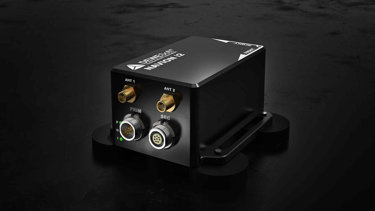
NAVION i2 is a Dewesoft inertial navigation system (INS) platform that provides accurate position, orientation, velocity, and acceleration measurements. Measurements are estimated by a Kalman-based algorithm that combines GNSS positioning with the measurements provided by the internal MEMS-based inertial measurement unit (IMU). NAVION i2 is connectected to a PC via a connection box or Y-cable, both provided in the package.


In its size and weight class, NAVION i2 is the world's highest-performance inertial navigation system. The package includes a dual antenna for heading and RTK correction, which improves positioning accuracy down to 1 cm.
DewesoftX software makes it easy to configure NAVION i2 and to view and record its data. This award-winning software package is included, and can also record data from analog and digital sources and bus data like CAN and CAN FD, completely synchronized with the inertial data.
NAVION i2 can be affixed using either a magnetic mount or powerful suction cups, depending on the application. It supports all major constellations, including GPS L1, L2, L5; GLONASS L1, L2, L3; BeiDou B1, B2; Galileo E1, AltBOC, E5a, E5b; and NavlC (IRNSS) L5. It also supports several SBAS systems for enhanced accuracy.


Navion i2 provides accurate position, velocity, acceleration, and orientation even under the most demanding operating and environmental conditions. It is designed to operate across a wide variety of applications and industries, including automotive, aerospace, railway, and marine, as well as agriculture, transportation, industrial equipment, and robotics.
Designed for real-world outdoor applications, NAVION i2 is rated to IP68 water-proof and dust-proof specifications under the IEC 60529 standard. The small chassis weighs only 310 g (0.68 lbs).
Navion technical specifications
Please visit NAVION technical specifications page for full specs.